The Lost City of Atlantis Found at Last
The story of the lost city of Atlantis has been an enduring mystery for over two thousand years. The tale of a fantastically advanced civilisation from pre-history that was destroyed almost overnight in an immense global cataclysm. According to the ancient Greek philosopher Plato (428-347 BC) the event occurred circa 9600 BC [1]. The date itself being preserved by the Egyptian priests of Sais.
In his account of the Atlantis story, Plato references the occasion when Solon (630-560 BC), the famous lawgiver of Athens, visited Sais and spoke to its priests concerning various legends of old, including The Great Deluge.
As the subject unfolded, Solon was told that the Earth had been subject to violent devastation many times. And that this was entirely natural, due to the regular orbits of the planets being subject to periodic disruption. Moreover, that Atlantis itself had been directly destroyed by one of these cyclical upheavals.
Atlantis, the Legend
Now certainly there are those who believe that the lost city of Atlantis is not lost at all, but rather does not even exist. Not the position of this present author to be sure, who would not be writing this essay without working towards a very tangible proof.
Herein one may begin by noting that the cited date for the destruction of Atlantis accords well with the documented end of the Younger Dryas period. A time of sudden climatic change, when global temperatures shot up around the world by some 10°C in just a decade or so [2]. Quite a number of radiocarbon studies have fixed the Younger Dryas end-date as follows [3]:
Years Ago - Location
11500 - GRIP ice core, Greenland
11530 - Krakenes Lake, western Norway
11570 - Cariaco Basin core, Venezuela
11570 - German oak/pine dendrochronology
11640 - GISP2 ice core, Greenland
From the above, the average value = 11562 years Before Present (BP)
NB: The accepted scientific standard for ‘The Present’ = 1950 AD. Thus: The Younger Dryas end-date = 1950 – 11562 years
= 9612 BC
Quite clearly the Younger Dryas end-date is practically a perfect match to when Plato said Atlantis was destroyed. The implication being some sort of causal connection. Of course one would have to go well beyond simply an increase in global temperature to account for its demise. Indeed, one of the key components of the Atlantis story is that it was destroyed suddenly in a mighty deluge. Given this, a massive geophysical event alongside a severe temperature increase must have ultimately caused the end of the Younger Dryas period, were Atlantis real.
Atlantis Destroyed
In light of the above, one is compelled to suggest a means by which the Earth could be subject to immense geophysical destabilisation. And it is here that the priests of Sais cited by Plato provide the answer: A disruption to the orbits of the celestial bodies.
In this regard one may note that certain special conjunction patterns are indeed capable of causing a general resonant agitation of the whole solar system, with one pattern in particular being of extreme significance; shown previously to be linked to many destructive earth-changes over the recent geological period:
An alignment of Mars, Venus, the Sun and Mercury – all closely targeting the galactic centre, with the Sun and the Earth separately aligned near to the Pleiades star group:

10964 BC - Younger Dryas Start (Cometary Bombardment)
9621 BC
9612 BC - Younger Dryas End (Global Temperature increase)
8438 BC
7650 BC - Cometary Bombardment
6467 BC - Global Floods & Volcanoes
5124 BC
3941 BC - Intense Aridisation
3153 BC - Comet Strike
1970 BC
627 BC
557 BC - Comet Strike
1345 AD - Cometary Stream Bombardment
What is clearly implied here then, is that the above noted ‘Galactic-Pleiades’ alignment was directly responsible for causing the destruction of Atlantis circa 9600 BC. Being capable of triggering all of the necessary (extreme) geophysical effects required to achieve this end.
Now one may note that although the core pattern is comprised of just the 4 inner planets: Mercury, Venus, Earth & Mars, the other planets are not necessarily neutral when the configuration manifests. Indeed, they may well be so arranged as to contribute to the overall pattern, providing additional conjunctions to heighten its destructive power. The key alignment of 9621 BC demonstrates this very point.
With the pattern optimised to the 3 body alignment of Mars, Venus & Mercury, the precise date of the configuration is 30 July 9621 BC:

One can see that in addition to the core pattern of the 4 inner planets, there is a remarkable further alignment of Ceres and Jupiter with the sun, almost perfectly at 90 degrees to the main alignment.
Overall then, it is suggested that this pattern was not only responsible for affecting a sudden change in the energy output of the sun, thereby causing a global temperature increase, but also of creating a powerful global seismic disturbance that led to entire continents rising and falling.
Atlantis Underwater
According to Plato, prior to its destruction Atlantis was located out beyond ‘The Pillars of Hercules’ (i.e. The Strait of Gibraltar). An island larger than both Libya and Asia combined. Of course in ancient times neither of these two landmasses were as large as recognised in the modern era. Be that as it may, Atlantis was held to be an island of some scope.
In his account of its final destruction, Plato noted that it was preceded by “earthquakes and floods of extraordinary violence.” Following which, “in a single dreadful day and night… Atlantis was swallowed up by the sea and vanished.” [4]
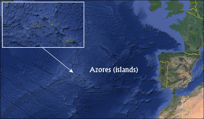
To answer the question then, where was Atlantis prior to its destruction, one must identify a landmass presently underwater, which in very ancient times (pre 9600 BC) was not, giving due consideration to both changing sea levels and seabed topography. With this in mind, the search for Atlantis has led many to consider the Azores plateau in the mid-Atlantic to be the crucial site.
Now certainly no large “country-sized” landmasses exist within the Atlantic today. There are however various small island groups scattered about; one of the most noteworthy being the Azores. A discreet group of islands sat upon a raised plateau, named after the islands themselves:
It is interesting to note then that if one models a far lower global sea level – e.g. approximately 2500 meters lower – then the Azores plateau is no longer under water, but emerges as a very prominent landmass (Below).
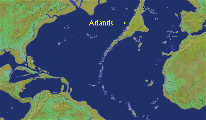
Now this modelling is not to suggest that a change in sea level alone forced Atlantis underwater. It is likely that the whole plateau collapsed downwards through extreme seismic activity, in addition to a change in sea level. It may be indicative though of the general size of the island as would have been above water, prior to sinking.
The City of Atlantis - The Heart of the Empire
Although the Azores plateau in the deep past is an exceptional Atlantis contender, it is certainly not the only one. There is a very good case however that it is indeed the correct solution, as will hopefully be demonstrated shortly.
Before proceeding however, one must first acknowledge the loose nature of the term Atlantis itself, oftentimes used interchangeably to refer either to the island of Atlantis, or to the capital city of Atlantis. And this is where things get very interesting.
Certainly there is nothing too remarkable or decisive in just pointing to a large undersea landmass and declaring it to have been the home of a once great civilisation. If one could isolate however the precise location of the remnant capital, then truly one would have a remarkable find.
The real quest is thus not for the lost island of Atlantis, but rather the lost city of Atlantis. The search for the very capital of the Atlantean empire itself.
Plato’s Description of Atlantis
In his description of the Atlantean capital city, Plato states that at its heart was a special citadel composed of a series of alternating rings/zones of land and water.
Quite remarkably, he goes into great detail about the dimensions of these zones, including the full diameter of the complex itself. Beginning with the outermost zone and working his way inwards, Plato writes the following (cited from Critias):

Now the largest of the zones into which a passage was cut from the sea was three stadia in breadth, and the zone of land which came next of equal breadth; but the next two zones, the one of water, the other of land, were two stadia, and the one which surrounded the central island was a stadium only in width. The island in which the palace was situated had a diameter of five stadia.
In view of these details the first thing to note is the actual length of a Stadia (or stadium), which is equal to some 600 feet (standard British feet) – this being the ancient Greek stadia [5]. Consequently, the width of each of the zones in sequence, expressed in feet, is as follows:
1800 - Water
1800 - Land
1200 - Water
1200 - Land
600 - Water
1500 - Land (the radius of the central island)
If all of the values are added together and multiplied by 2, the effective diameter of the whole site is some 16200 feet.
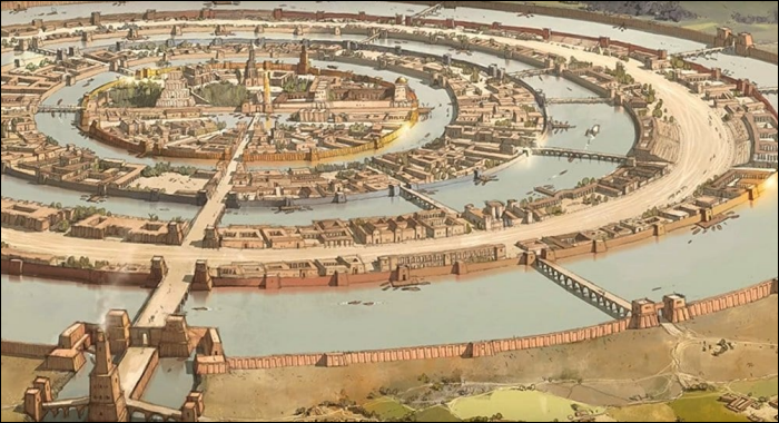
Beyond just a basic description of the Atlantean rings, Plato further notes that each were connected via a series of bridges, allowing passage all the way to the central island. Indeed, many artists have produced a variety of images over the years to try to capture just what the city might have looked like during its heyday, bridges included. One such example is as follows:
Atlantis Found
If the whole island of Atlantis sunk beneath the waves due to a global cataclysm, then one should certainly expect to find the city of Atlantis underwater. And herein many attempts have been made over the years to locate its undersea ruins. Only in recent years though have certain tools been available to Atlantis researchers that previously were inconceivable.
Most people are no doubt familiar with Google Earth, which provides satellite imagery of the whole globe based upon a variety of surveys. Not only does it allow viewers to examine various landmasses for navigation purposes, it also reveals the general topography of the ocean floors. It is certainly not the only program that does this however.
Quite a number of websites provide detailed surveys of the ocean floors, offering very respectable resolutions. Many researchers have thus took to scouring them for any underwater anomalies they can find, which just might prove to be the elusive remains of the city of Atlantis.
Here it is then, that a great discovery would recently appear to have been made.
Now certainly, credit where credit is due. In the section that follows, this present researcher is citing the critical finding of another, giving them full recognition for their discovery.
The Azores Plateau Anomaly
In late December of 2020, opening up a thread on the Graham Hancock ‘Mysteries' message board, an Atlantis researcher named Mathew Chinn presented a new theory concerning the location of Atlantis.
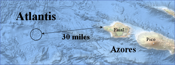
From an extreme close up one can see the anomaly in some detail. A circular structure with at least 1 distinct inner ring. The precise centre-point of the site is given as latitude 38.535 North, longitude 29.4025 West:
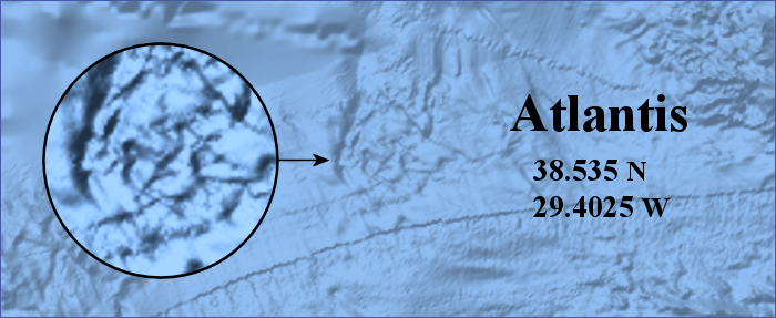
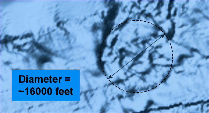
Now the very first thing to note concerning the structure is that its diameter would appear to be a very close match to the Atlantis diameter given by Plato: 27 Stadia, or 16200 feet. This is based upon the line of best fit in terms of marking the circular circumference of the feature:
In his analysis, Mr. Chinn has looked very carefully at Plato’s works concerning the location of Atlantis. Studying not just the city complex itself but also the surrounding terrain and nearby sea. With his You Tube channel established, he has posted a whole series of videos evaluating the structure. A link to his channel is provided below in the notes section of this article.
Suffice it to say, to delve more deeply into this aspect of his work, I do recommend his videos. That being said, what follows next will be an evaluation of the undersea feature in line with the work of this present researcher: An analysis of its global placement to establish if it possesses an ‘energetic signature,’ in like manner to The Great Pyramid.
The Earth Energy-Grid Matrix
When one considers so many of the most prominent megalithic structures from the deep past, it is undeniable that they were positioned extremely carefully with respect to the dimensions of the Earth’s physical form. This being due to the fact that they were not mere artistic monuments, but functional energetic devices, specifically constructed to interact with the Earth itself via resonance, allowing them to tap into the natural energy fields of the planet.
Now the energetic significance of such structures is revealed most decisively via an associated ‘cuboid’ grid matrix. In this regard, one may consider any given point upon the Earth as the vertex of a cuboid embedded within the planet’s ellipsoid interior: 1 out of 8 points in total, as shown below, Top Left:
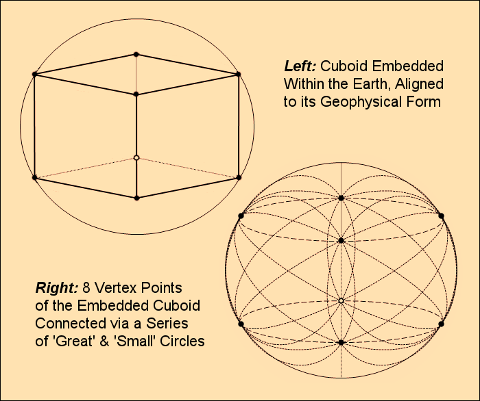
The key dimensions of such a cuboid are determined by the pure latitude of its vertex points, whether above or below the equator. If their latitude were only slightly removed from the equator, then the cuboid would have 4 thin rectangular sides, with 2 large squares – top and bottom. If on the other hand the cuboid’s vertex points were near to the poles of the physical Earth, then its top and bottom squares would be very small, though again with thin rectangular sides. Somewhere in the middle of these two extremes, were the cuboid’s vertex points about half way between the equator and the poles, then it would closely match a perfect cube, as with the example diagram above.
With such a form embedded within the Earth, one can connect up all of the vertex points via a whole series of ‘great’ and ‘small’ circles, as shown above, bottom right. In doing so, one has the key to revealing the high science behind some of the greatest and most mysterious monuments of the ancient world, including certain modern-day buildings of interest.
Whether one is evaluating ancient megaliths or even present-day military-intelligence facilities, one can oftentimes determine their special (esoteric) significance by analysing the arc-length measures of their associated cuboid grid matrix. The kind of analysis which has already been done elsewhere on this site, respecting both The Great Pyramid and The Maoling Pyramid of China.
In the case of both structures, the arc measures linked to both grid patterns were shown to possess a special harmony to the Earth itself, indicative of an energetic association with the planet. The implication being that both ancient pyramids were devices of some sort.
Now it would appear that this is also the case with respect to the Atlantis site, as identified by Mr. Chinn.
The Tuaoi Firestone Crystal of Atlantis
To confirm that the lost city of Atlantis truly has been found, one would ideally seek a close inspection of the site via a submersible craft. A difficult prospect to be sure given a depth of some 5900 feet. The artificial nature of the complex must therefore be established indirectly, and this is where an ‘Earth-Grid’ analysis comes in.
There is of course a crucial assumption being made here: that at the very heart of the city of Atlantis, there was an energetic megalithic monument of some description. Well here indeed, we can cite Plato himself for confirmation of this; his depiction of the city noting the key structure in question:
The palaces in the interior of the [Atlantis] citadel were constructed on this wise:- in the centre was a holy temple dedicated to Cleito and Poseidon, which remained inaccessible, and was surrounded by an enclosure of gold; this was the spot where the family of the ten princes first saw the light, and thither the people annually brought the fruits of the earth in their season from all the ten portions, to be an offering to each of the ten. Here was Poseidon's own temple which was a stadium in length, and half a stadium in width, and of a proportionate height, having a strange barbaric appearance. All the outside of the temple, with the exception of the pinnacles, they covered with silver, and the pinnacles with gold.
In addition to Plato’s account of Atlantis, there is also an important reference by Edgar Cayce worth mentioning. Now certainly those familiar with Atlantis research will not be unaware of Cayce – one of the greatest psychics of the modern era – who practically needs no introduction. (Though certainly, if one does wish to seek out more information on him, one can look elsewhere). Further reinforcing the point that Atlantis used ‘esoteric technology,’ one may consider a summary of one of Cayce’s readings:
Out of the thousands of readings channelled by Edgar Cayce, reading 440-5, a life reading, is one of the most interesting. Channelled on December 20th, 1933, it gives a description of a giant crystal on Atlantis that was, apparently, at one time, its main power source, among many other uses it had throughout the long history of Atlantis. This crystal is also called a "firestone" and in another reading, it is named the Tuaoi stone. This firestone, could concentrate the energy emanating from the sun and other stars, combine this energy with other elements, store it, and use it… [6]
It is no stretch of the imagination to suggest that the Tuaoi Firestone would have been at the centre of Poseidon’s temple, and with a functional link to the structure itself. Accepting the truth of this, in line with all of the research on other functional megaliths, the lost city of Atlantis itself had to have been built at a very special location. A site of global significance.
The Earth-grid Matrix of Atlantis
Under an Earth-grid matrix analysis, there can be little doubt that the proposed Atlantis site was chosen with extreme care. The inescapable conclusion being that it is indeed an artificial site. Nothing less than the legendary city of Atlantis itself. Now this is evidenced when one considers the strong link between its associated arc measures, and the key mathematical values of the Sumerian base-60 system.
Herein one may begin by noting a special relationship between the Atlantis site and The Great Pyramid, as based upon their respective latitude values:
The Great Pyramid:
Latitude: 29.980833333… North (29 deg. 58 min. 51 sec.)
Elliptical arc up from the equator = 10885789.7940 feet
Atlantis Site:
Latitude: 38.535 North
Elliptical arc up from the equator = 13998962.7512 feet
Ratio = 10885789.7940 / 13998962.7512 = 0.7776140266
Divided by 6 successively...
0.1296023377
0.0216003896
0.0036000649
0.0006000108
The sequence thus refined to its optimum is:
0.1296
0.0216
0.0036
0.0006
Clearly one can surmise the targeted ideal initial ratio: 0.7776
Consider the longitude separation arc of both sites at the equator, relative to the equator itself:
Equatorial (circular) Earth Circumference (WGS84 Model): 131479713.5353 feet
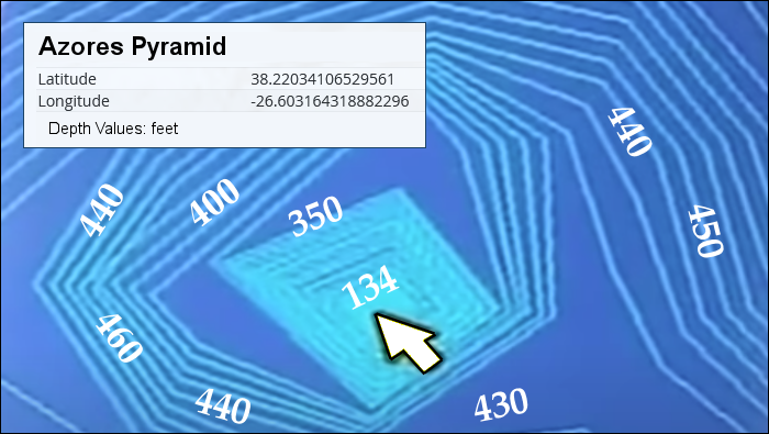
The Azores Pyramid: Longitude: 26.603164318882296 West
Atlantis Site: Longitude: 29.4025 West
Longitude (circular) separation arc at the equator:
29.4025 W to 26.603164318882296 W = 1022377.3705 feet
Ratio between separation arc and equator:
1022377.3705 / 131479713.5353 = 0.007775932446
Divided by 6 successively...
0.001295988741
0.000215998123
0.000035999687
0.000005999947
The sequence refined to its optimum is thus:
0.001296
0.000216
0.000036
0.000006
Clearly the optimum initial ratio is equal to 0.007776. A basic variant of the above noted latitude arc ratio of 0.7776.
In addition to these relations, there is also a close link between the latitude arc of the Atlantis site, and the Earth’s equatorial circumference. This involves use of the basic prime number 11 in order to ‘latch on’ to the main Sumerian sequence:
Atlantis site elliptical arc up from the equator = 13998962.7512 feet
Earth Equatorial Circumference = 131479713.5353 feet
Ratio = 131479713.5353 / 13998962.7512 = 9.392103963123
9.392103963123 × 11 = 103.3131435943
Divided by 9 successively...
11.479238177151
1.2754709085723 < NB this ratio
0.1417189898413
0.0157465544268
0.0017496171585
0.0001944019065
0.0000216002118
And then divided by 6...
0.0000036000353
0.0000006000058
The sequence refined to its optimum:
11.4791256
1.2754584
0.1417176
0.0157464
0.0017496
0.0001944
0.0000216
0.0000036
0.0000006
Once again, one can see a clear link to the primary values of the Sumerian base-60 system. In particular one may note the highlighted ratio 1.2754709085723. In the previous analysis of the Azores pyramid, this exact same ratio was also evident; derived via the following connection:
The Great Pyramid:
Latitude: 29.980833333… North (29 deg. 58 min. 51 sec.)
Elliptical arc up from the equator = 10885789.7940 feet
Azores Pyramid Site:
Latitude: 38.22034106529561 North
Elliptical arc up from the equator = 13884368.6375 feet
Ratio between the two values = 13884368.6375 / 10885789.7940 = 1.275458088044
When compared with 1.2754709085723 above, it is obvious that they are both associated with the same ideal: 1.2754584.
Staying with the Azores pyramid latitude, one may note a further link of great significance. A special tie-in to the Atlantis latitude and a key component of its cuboid grid matrix. Specifically, an association involving the latitude separation of both sites, and the great circle arc connecting up Atlantis to an adjacent vertex point of its matrix (detailed in red):
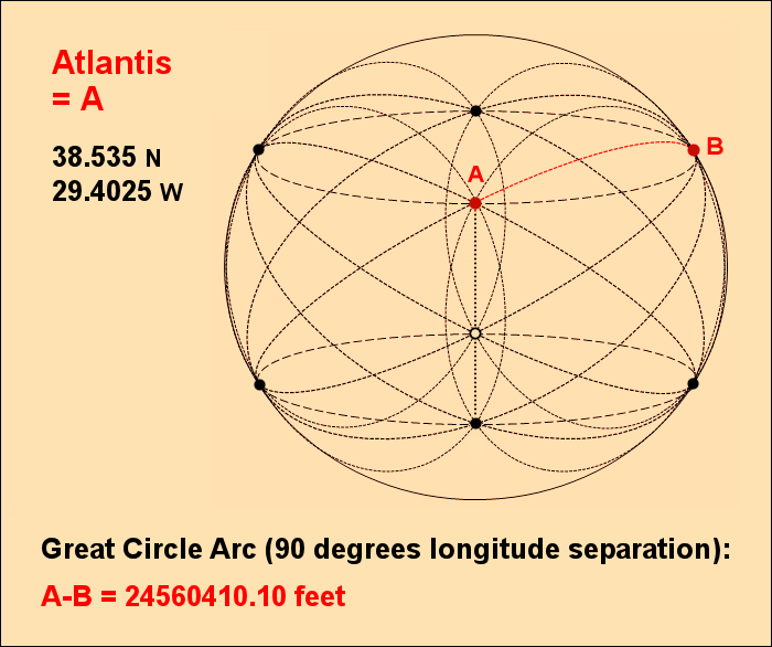
Great Circle Arc (90 degrees longitude separation) A-B (detailed above)
= 24560410.107 feet
Latitude Separation: Azores Pyramid to Atlantis: 38.535 N to 38.22034106529561 N
= 114594.11366 feet
Ratio = 114594.11366 / 24560410.107 = 0.0046658061963
Certainly one cannot fail to see how close this value is to an exact 0.0046656. A value which successively divided by 6 produces the primary sexagesimal sequence:
0.0046656
0.0007776
0.0001296
0.0000216
0.0000036
0.0000006
Now one may note here just how accurate this relation is by considering the latitudinal adjustment necessary to perfectly attain the 0.0046656 value. All that is required is to simply shift the latitude of the Azores pyramid 5 feet northwards, thereby reducing the separation arc of the two sites from 114594.11366 feet to 114589.04939 feet.
The Temple of Atlantis Harmonic
Further to the above, one may also note a critical association between the latitude arc of the Atlantis site and the temple of Poseidon itself, as located at its centre. Just as with The Great Pyramid, a key dimension of the structure would appear to have been deliberately chosen to fit harmonically into its latitude arc. Once again with a strong tie-in to a very familiar sequence:
Atlantis Site:
Elliptical arc up from the equator = 13998962.7512 feet
Temple of Poseidon:
Width = Half of 1 Stadium unit = 300 feet
Ratio = 13998962.7512 / 300 = 46663.2091
Quite clearly one can surmise the ideal intended value: 46656
Divided by 6 successively: 7776, 1296, 216, 36, 6
The Lost City of Atlantis in Summary
In light of the above earth-grid analysis, it would appear that the underwater artefact, as identified by Mr. Chinn, is certainly not an incidental natural formation, but clearly an artificial structure.
Conforming to the basic diameter of the Atlantis citadel, as detailed by Plato, the precise location of the site is found to possess a variety of mathematical properties. Its associated arc length measures, as tied to the Earth, including various prominent megaliths from around the world, all point inescapably to an energetic signature.
Quite clearly, the suggested site manifests the very same kinds of mathematical relations found at The Great Pyramid, the Chinese Maoling Pyramid, and even the Azores Pyramid. The strength of the relations allowing one to state with confidence, that The Lost City of Atlantis has indeed been found, and this is the site:
Notes
[1] From Plato’s works the Timaeus and Critias.
[2] NOAA: Younger Dryas
[3] Wikipedia: Younger Dryas
[4] Plato ibid.
[5] Things are certainly being simplified here, as there are many ancient Stadia units, with slight differences between them. Without losing oneself in such minutiae however, the ancient Greek Stadia composed of British feet would appear to be the correct solution.
[6] Atlantis Tuaoi Stone
Special Note
To examine the research of Mathew Chinn concerning the Atlantis site, the link to his You Tube channel is: Apocalypse Channel