The Azores Pyramid - Megalithic Monument
In September of 2013 a rather remarkable discovery was made of a large underwater pyramid close to the Azores islands in the mid-Atlantic, located roughly between São Miguel and Terceira. The chance finding of one Diocleciano Silva, a private yacht owner. The story was so intriguing that a Portuguese TV news crew interviewed Silva concerning his find, which he detected via bathymetric navigation. What exposed the public to the Azores pyramid for the first time.
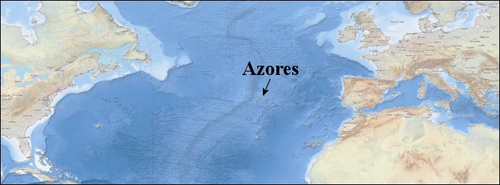
The initial reports of the Azores pyramid placed it very close to the Bank De João de Castro, an underwater seamount that almost pierces the surface. Its highest point at a depth of only some 45 feet.
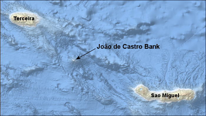
Between the two islands of São Miguel and Terceira, the João de Castro Bank is the only undersea feature to even come close to the surface of the ocean. All other surrounding undersea structures are at least 1600 feet deep.
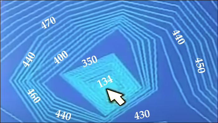
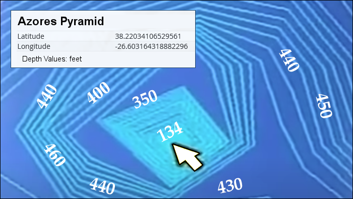
According to the bathymetric survey conducted by Silva, the Azores pyramid has a base size of some 8000 square metres, with a height of about 60 metres. It is also orientated to the 4 geophysical cardinal points of the Earth – just like The Great Pyramid. From an image of Silva’s survey (shown below), the apex of the pyramid is about 134 feet beneath the surface (~40 metres), with the base at a depth of some 350 feet (~106 metres):
Where is the Azores Pyramid Exactly?
It is very noteworthy that since discovering the Azores pyramid, Silva does not appear to have ever publicly disclosed its precise location, even to this day. Choosing instead to reveal the details only to the Portuguese Navy for further investigation. A fact which may well explain why no other private individuals have ever returned to the site. The only information thus available on the pyramid is that it is somewhere near to the Bank De João de Castro, and that its apex is about 40 metres underwater (~134 feet).
Now absent any official release of the pyramid’s co-ordinates, in terms of isolating its precise location, one could be forgiven for thinking that these details are simply too vague to be of use. Quite the contrary. In point of fact they narrow down the search area immensely. Indeed, the De João de Castro seamount zone that the pyramid would have to be situated within, based upon the depth profile of Silva’s survey, is an area only some 2250 by 2250 feet.
An ‘Earth-grid’ Analysis of the Azores Pyramid
Now were the Azores pyramid once a functional device like The Great Pyramid, one would certainly expect it to be very carefully sited, occupying an exceptional point about the seamount area. One that would allow for certain energetic effects to be achieved via a special harmonic link to the Earth itself. In this regard, an ‘Earth-grid’ analysis would therefore be just the thing to determine its location, absent any official co-ordinates.
In studying the area around the João de Castro Bank region, one is thus after a very select point intimately linked to the core mathematical values of the ancient Sumerian (base-60) system. A special association involving a combination of ‘great circle’ arc measures and ratio values; all of which confirm the exceptional quality of the site. Nothing less than the prime contender for the location of the Azores pyramid, against all other possibilities.
In evaluating the undersea topography of the João de Castro Bank seamount, it would appear that there is indeed just such a site; hereby put forward as the location of the pyramid:
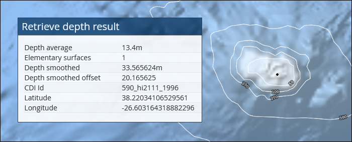
From the referenced bathymetry survey, one may note that the resolution is certainly nowhere near on par with Silva’s own. Even so, one can still see a close correspondence between the ‘smoothed value’ depth of 33.565 metres, and the 40 metres cited by Silva himself. In this instance, the noted location is near to the southern part of the seamount, just before the depth begins to rapidly increase as one moves further south.
The Great Pyramid Connection
In previous articles concerning The Great Pyramid and the US Echelon sites in Australia and the UK, the physical significance of an Earth-grid analysis was well documented. And one may certainly consult these articles in-depth for more information.Suffice it to say here, this present article will proceed directly to the mathematical analysis, revealing the key associations that decisively confirm the significance of the proposed site; being the most optimum within the region and the likely site of the Azores pyramid.
To begin, one may consider a series of great-circle arc measure relations, each demonstrating a close affinity to the primary values of the Sumerian base-60 system: 6, 36, 216, 1296, 7776, 46656…
The Proposed Location of the Azores Pyramid
Latitude: 38.22034106529561 N
Longitude: 26.60316431888229 W
With so many ancient megalithic monuments around the world apparently tied together in a global network, it should come as no surprise to find that this location is directly linked to The Great Pyramid.
Consider then the ratio of the elliptical arc measures of both sites up from the equator:
The Great Pyramid:
Latitude: 29.980833333… North (29 deg. 58 min. 51 sec.)
Elliptical arc up from the equator = 10885789.7940 feet
Azores Pyramid Site:
Latitude: 38.22034106529561 North
Elliptical arc up from the equator = 13884368.6375 feet
Ratio between the two values = 13884368.6375 / 10885789.7940 = 1.275458088044
Now the key value as derived here – though not immediately obvious – has a very close correspondence to the primary base-60 sequence. This is evident when one divides it successively by the number 9, followed by the number 6:
Divided by 9 successively…
1.275458088044
0.141717565338
0.015746396148
0.001749599572
0.000194399952
0.000021599994
Divided then by 6…
0.000003599999
0.000000599999
The sequence thus refined to its optimum is:
1.2754584
0.1417176
0.0157464
0.0017496
0.0001944
0.0000216
0.0000036
0.0000006
Now the above correspondence is exceptional. And with only a 4 feet latitude shift of either the Azores site or The Great Pyramid, the given ratio would be perfect (exactly 1.2754584).
It is important to note here though, that in exploring the best location for the Azores pyramid, this present researcher – I myself – deliberately chose this site on the João de Castro Bank. I thus refined the latitude specifically to get this exceptional correspondence. In this regard one could absolutely accuse me of manipulation.
That being said, it turns out that in choosing the co-ordinates in question to achieve the noted ratio, a series of additional relations emerge that stand entirely on their own merits, without any deliberate manipulation on my part, or even foreknowledge of their existence. It is these extra relations – taken together – that provide powerful evidence of the significance of the chosen site.
The Azores Pyramid & The Cuboid Grid Matrix
As previously revealed elsewhere, many prominent ancient megaliths are globally sited to establish certain special arc length measures over the Earth’s surface, specifically linked to a cuboid grid matrix. This is where the given structure in question is positioned at one of the vertex points (1 of 8) of a cuboid embedded within the Earth.
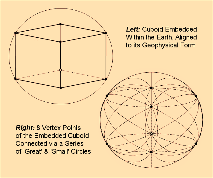
Depending upon the selected latitude of the structure, either above or below the equator, all of the 8 points of the cuboid are fixed relative to one another, including the Earth itself.
One of the tell-tale signs that an ancient megalith was built as a ‘functional device,’ is that the great circle arcs connecting up the various vertex points of its cuboid matrix, are either directly or indirectly related to the key values of the Sumerian system, or produce 'basic' mathematical ratios. In this regard then, with the suggested latitude of the Azores pyramid, a very intriguing ratio is to be had between two components of its associated cuboid matrix. This is based upon the following two arc measures, as depicted in red (below):
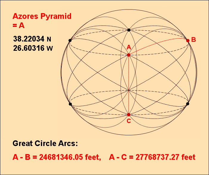
1) The Great Circle arc between points A & C:
Point A is the suggested site of the Azores pyramid, at 38.22034106529561 North.
Point C is its mirrored vertex point at 38.22034106529561 South. Both points are on the same longitude: 26.603164318882296 West.
A-C Great Circle Arc = 27768737.27 feet
NB: In the diagram, A-C looks like a straight line connection between the two points, but this is deceptive; based purely upon the perspective of the viewer/diagram. The line is actually a curved arc over the Earth’s surface.
2) The Great Circle arc between points A & B:
Points A and B are both on the same latitude: 38.22034106529561 North.
Point A is at longitude: 26.603164318882296 West, with Point B exactly 90 degrees eastwards, at 63.396835681117704 East
A-B Great Circle Arc = 24681346.05 feet
With the two arc measures noted, consider then the ratio between them:
24681346.05 / 27768737.27 = 0.8888177310
Based upon the numeric sequence, the suggested ideal is obvious: 0.8888888... exact, which is the precise fraction 8/9.
In terms of the margin of error, one may note that were the suggested latitude of the Azores pyramid at 38.218445 N, then the ratio of the two adjusted arc measures would be precisely 8/9 (0.8888888…). This would constitute a positional shift of some 690 feet to the south. Only a small adjustment to be sure.
It is hereby suggested then that the builders of the pyramid, in situating it where they did, were fully aware of both noted relations. The ratio of 1.2754584, as linked to the latitude of The Great Pyramid, and also 0.888888… based upon the Azores pyramid’s ‘stand-alone’ cuboid matrix.
Now one might wonder why the builders did not accommodate both ratios equally – or rather as best they could – by choosing a mid-point latitude, as would distribute the error +/- 345 feet from each site. Well indeed, there are other additional mathematical relations still to consider. The quality of which may well have persuaded the builders to ultimately select the precise latitude of 38.22034106529561 N, thereby deliberately perfecting the 1.2754584 ratio over the 8/9 ratio.
The Earth Equator Association
The most important great circle of all is without doubt the Earth’s own equator, which is a true circular measure. All other great circle variants are elliptical.
It is often the case then with important megalithic sites, that the arc values linked to their cuboid grid matrices have a special ratio connection to the Earth’s equator. And this definitely proves to be the case with the suggested site of the Azores pyramid, once again with respect to its latitude measure:
Azores Pyramid latitude arc = 13884368.63 feet
Earth’s equatorial circumference (WGS84) = 131479713.535 feet (24901.46089 miles)
Ratio = 13884368.63 / 131479713.535 = 0.1056008433
From this, the next step to link to the core values of the Sumerian system is to divide the ratio by the basic prime number 11:
0.1056008433 / 11 = 0.0096000766
And then divide by 4, twice:
0.0024000191
0.0006000047
Using each of the noted modifiers in sequence, the ideal progression is thus as follows:
0.1056
0.0096
0.0024
0.0006
The key ideal ratio then is 0.1056, which is the basic fraction 66 / 625.
Further to this, one may note that the ‘on the ground adjustment’ as would derive this exact fraction, is a latitude shift 110.88 feet south of the suggested Azores Pyramid site.
The Atlantis Connection
In a previous article on the location of The Lost City of Atlantis, in pursuing an Azores solution, it was suggested that the ancient city was some 30 miles west of the island of Faial. The precise co-ordinates shown in the image below: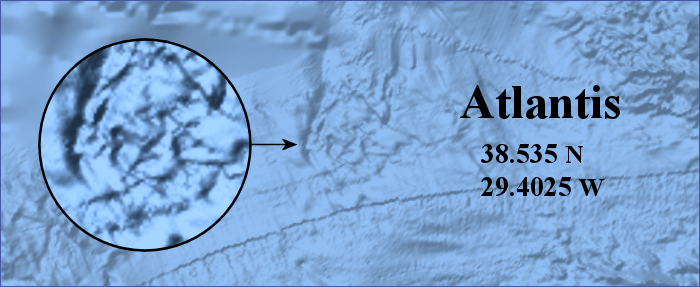
Now it was also noted in the article that at the centre of Atlantis was a temple to Poseidon, which itself was a functional megalithic structure with a special crystal at its heart. It is no stretch of the imagination to think then that there might be an energetic connection to the Azores pyramid, which is only some 153 miles due east of the Atlantis site.
Well there are in fact a few relations of note between the two sites. One based upon the pure latitude arc separating them, and another on the longitudinal arc of separation (at the equator).
One may begin by considering first the former:
Atlantis Latitude = 38.535 N
Azores Pyramid latitude = 38.22034106529561 N
Pure latitude arc separation = 114594.11366 feet
With this value in hand then, consider one of the great circle arc measures of the Atlantis cuboid grid matrix: The ‘90 degree separation arc’ of two of its vertex points, as shown below in red:
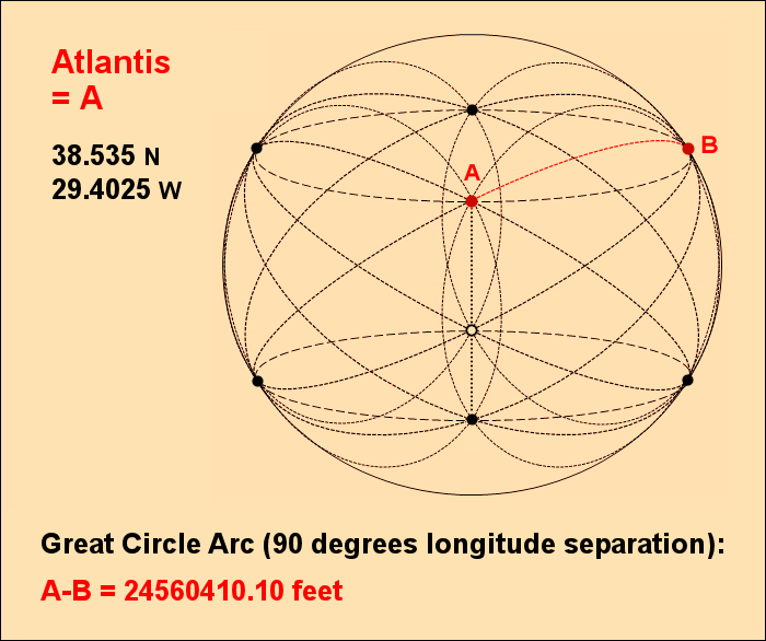
A simple division using both noted measures reveals an almost instantly recognisable value:
114594.11366 / 24560410.107 = 0.0046658061963
The obvious ideal = 0.0046656
Successively divided by 6, the direct tie-in to the primary values of the Sumerian system is as follows:
0.0007776
0.0001296
0.0000216
0.0000036
0.0000006
With respect to this association, one may note that were the suggested Azores pyramid site shifted latitude wise only some 5 feet northwards, then the ideal ratio of 0.0046656 would be obtained.
The Atlantis-Azores Longitude Connection
In addition to the above, one may also consider the pure longitude separation of the two noted sites. In this instance at the plane of the equator:
Atlantis Longitude = 29.4025 W
Azores Pyramid Longitude = 26.603164318882296 W
Equatorial arc separation = 1022377.3705 feet
Note the ratio between this and the full equatorial circumference of the planet:
1022377.3705 / 131479713.535 = 0.00777593244
Successively divided by 6…
0.001295988741
0.000215998123
0.000035999687
0.000005999947
The ideal progression:
0.007776
0.001296
0.000216
0.000036
0.000006
Now one must acknowledge that the 0.007776 association only exists due to actively selecting the Azores pyramid longitude in question i.e. 26.603164318882296 W. One could definitely therefore be accused of cherry picking to artificially produce the noted connection.
That being said however, there does exist an independent supporting link to confirm the veracity of the chosen longitude. A special association involving the great circle arc directly linking up the Atlantis site to the suggested Azores pyramid site:
Atlantis to Azores pyramid: Direct great circle separation = 810620.97016 feet (153.52 miles)
Consider the ratio between this and the already noted pure latitude separation of the Atlantis site to the Azores pyramid: 114594.11366 feet.
114594.11366 / 810620.97016 = 0.1413658391
Multiplied by 11 = 1.5550242304
Divided by 2, and one is instantly confronted by a very familiar value:
0.7775121152
Successively divided by 6…
0.1295853525
0.0215975587
0.0035995931
0.0005999321
The ideal progression:
0.7776
0.1296
0.0216
0.0036
0.0006
As this connection involves a ratio based upon the direct arc separating the two noted sites, it takes into account both longitude and latitude. As a result, it offers independent validation of the choice of the Azores pyramid longitude value.
The Azores Pyramid in Conclusion
Certainly there is no doubt in the mind of this present researcher that the Azores pyramid exists – that it is an authentic find. The key focus of this essay has thus only ever been to deduce the precise co-ordinates of the structure, absent any official release.
In this regard, with all the data presented, the case would appear to be very strong for the chosen site in question:
Of all of the sites within the swallows of the seamount area, it is this location that seems the most optimum. That which best accommodates so many key mathematical relations indicative of a (once) functional energetic megalithic monument. Indeed, the parallels with other structures of like character, including The Great Pyramid of Giza or the Maoling pyramid of China, are undeniable.
One can only wonder if at some future point in time, there will be a return to the Bank De João de Castro seamount, to explore the Azores Pyramid more fully.
References
The main source of information on the Azores Pyramid and its characteristics is the TV interview with Diocleciano Silva:
The Azores Pyramid TV Interview
The specific reference that the pyramid is located near to the Bank De João de Castro is from this archived website page:
The Azores Underwater Pyramid Location.