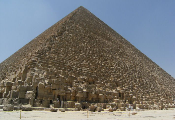
The Great Pyramid of Giza
Latitude Positioning & Proof of an Ultra Advanced Ancient Civilisation
As remarkable as it may seem, the precise global location of the Great Pyramid of Giza in Egypt proves beyond all doubt the existence of a highly advanced civilisation in ancient times. Carefully considered, just the singular fact that is the placement of this mighty megalithic structure forces one to conclude:
1) The builders possessed highly sophisticated knowledge of mathematics and geometry
2) Had knowledge of the true dimensions of the earth to extreme precision
3) Possessed exceptionally advanced technical instrumentation to site The Great Pyramid
As astounding as it may seem, in all three areas, the civilisation responsible for the monument was at least on par with the present age. Indeed, the mathematics employed to position the pyramid in ancient times would seem to have necessitated certain advanced breakthroughs in the field of geometry; such as were only recently discovered (or re-discovered) in the past few centuries. Moreover, the latitude placement of The Great Pyramid of Giza would appear to have been determined by a key ratio linked to the size of the earth; the exceptional accuracy achieved in realising this, implying that the builders knew the earth’s true dimensions to a level in accordance with the most advanced earth model developed in the modern era: The WGS84 earth ellipsoid model (World Geodetic System, established in 1984) [1].
Furthermore, in actually pin-pointing the location of the site at which to build the megalithic structure, highly sophisticated equipment would have to have been used. Simple stone and wooden tools as assumed by conventional historians could never have sufficed. Though difficult for some to accept, electronic instrumentation is not outside the bounds of possibility.
High Precision Placement of The Great Pyramid
Upon careful evaluation, there is simply no way that the precise positioning of the Great Pyramid was due to chance. And it is doubtful also that it was built as a local project purely for the local populous. Indeed, located exactly where it is upon the earth reveals the remarkable intent of the builders; their aim being to achieve a very elegant mathematical connection between the pyramid itself, and the earth form.
Where is The Great Pyramid of Giza located?
The co-ordinates of the structure under the WGS84 earth model are as follows:
29 deg. 58 min. 51 sec. of arc - North (Latitude)
31 deg. 09 min. 0 sec. of arc - East (Longitude)
Of the two noted values, the latitude is of greatest significance, as the placement of the pyramid north of the equator is the very thing that forces one to conclude the builders knew the true and exacting dimensions of the earth.
The Intent of the Pyramid Builders
Due to its axial spin the earth is an ellipsoid form, being a slightly squashed sphere with a marked equatorial bulge [2]. In consequence, all arc length measures from any point on the equator directly connecting up to either pole are complex elliptical curves. All arc length measures swept out over the surface of the earth on or parallel to the equator, are basic circular curves.
The critical point is: elliptical geometry is infinitely more complex to model than simple circular geometry. To place The Great Pyramid where they did the builders had to have possessed advanced mathematical knowledge in both areas; for this seems to have enabled them to locate the structure where they did in order to deliberately capture a certain special mathematical ratio. This being between two key measures swept out over the surface of the earth:
- The sum of 4 ‘great circle' arcs linking up the 4 points of a square, as set inside the 'small circle' circumference of the earth, at the latitude of the structure.
- The elliptical arc length up from the earth equator to the centre of the structure.
The draw out the critical relations as detailed here, one must realise that it is based upon the 'presence' of an embedded cuboid within the earth, wherein The Great Pyramid is situated at one of the 8 corner points of the cuboid itself. In this instance, both the top and bottom sections of the cuboid are squares, whereas the 'side sections' are rectangular. This is depicted in the diagram as follows:
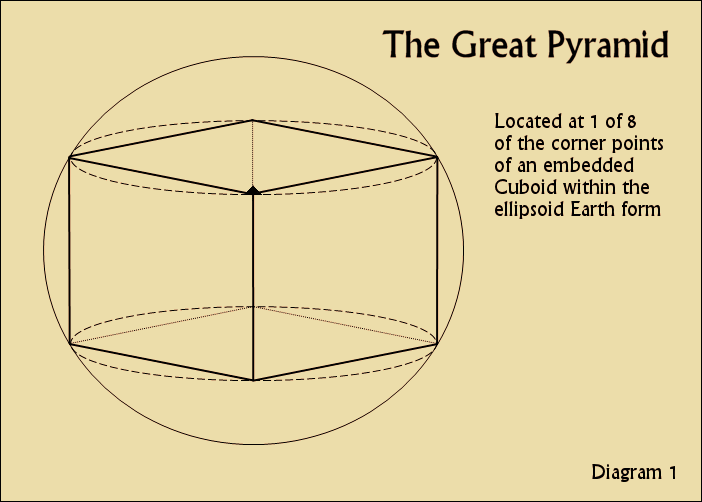
Now with this established, one can also note that the 8 corner points of the cuboid can be connected up by a series of 'great circles' over the ellipsoid earth form. In this instance in pairs, wherein two corner points of the cuboid in one hemisphere are linked to their opposite points in the other. Here then, with the cuboid form thus removed, and the 'great circle' arcs alone detailed, one now has the following:

What emerges here then is a complex shape to be sure. However, upon careful evaluation, it contains a critically important ratio between certain key components. One that would appear to be the governing ratio that the builders of The Great Pyramid used to site the structure globally. To draw this out, one must focus in on certain critical arc measures within the overall pattern, as follows:
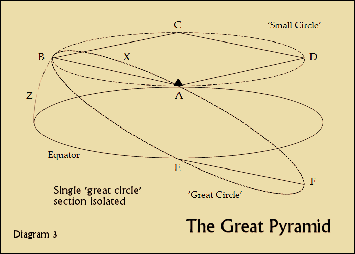
Here one can see then the critical relations of significance. Firstly, there is the elliptical arc up from the equator of the earth to the latitude of The Great Pyramid. This is marked as Z in the above diagram. Further to this, one can see one of the 'great circle' arcs in isolation, noting specifically the section of the arc connecting up points A and B, which is marked as X.
Now using the modern WGS84 earth ellipsoid model, one may consider the result obtained when one takes the value of X, as multiplied by 4, and divides it by the elliptical arc Z, from the equator to the latitude of The Great Pyramid [3]:
X × 4 = 20917.36136 miles
Z = 2061.702612 miles
Ratio = 20917.36136 / 2061.702612
= 10.14567340
Now the key value of interest here is the ratio, which indeed at first one might be tempted to dismiss as being of no importance. This would be a great mistake however, as the value appears to have immense significance. Specifically, the sequence of numbers that comprise it closely match those that make up none other than the ratio between the current earth tropical year, and an ideal value of 360 days:
365.2421897 / 360 = 1.014561638
Essentially, the noted ratio associated with The Great Pyramid is practically dead on 10 times the value for a change in the earth year from an ideal of 360 days to its present value.
Now it has previously been discussed at length in other articles that dealt with Egyptian astronomy, that the ancient Egyptians themselves were adamant in their belief that the earth did once possess a 360 day orbit. But that a fundamental shift or disruption to the cosmos in its early stages, altered the orbit of our planet, giving it its current tropical year of 365.2421897 days.
A Chance Relationship? I think Not
Now before anyone dismisses the above numerical match as due to coincidence, consider the margin of error. Let us judge the placement of The Great Pyramid as evaluated above, against what its latitude would have to be in order to capture a precise 10.14561638 ratio, as based upon the currently observed tropical year divided by 360 (x10).
To attain the exact ratio, the structure would have to be located at the precise latitude of 29:58:51.4477 North, with the two key earth measures as follows:
X × 4 = 20917.33070 miles
Z = 2061.711178 miles
Ratio = 20917.33070 / 2061.711178
= 10.14561638
The result reveals that to attain the value of 10.14561638 exactly, the monument would need to be moved slightly further north from its present position. Specifically:
2061.711178 – 2061.702612
= 0.008566 miles, or 45.22 feet.
Now one should consider this difference in light of the fact that the full base side-length of The Great Pyramid itself is some 756 feet. The difference is thus ‘contained’ within the structure as placed. Moreover, in terms of achieving a location based upon global considerations, one should also note that the true elliptical circumference of the earth (pole to pole) under the WGS84 model is 131259392.7 feet (24859.73347 miles).
Conclusions
In light of the above analysis one must conclude that the ratio of 10.14561638 (10 times the tropical year increase from 360 to 365.2421897 days) was intentional. The builders actively sought to realise this ratio between the two noted measures: (X × 4) / Z. The very latitude placement was thus determined by the ratio. It was the governing principle that led to it being built precisely where it was, north of the equator.
Knowledge of the Earth’s True Dimensions
Now it is critical to note that in accurately determining the elliptical arc distance from the equator to the centre of the pyramid, it is undeniable that the builders knew the dimensions of the earth form to our present day standard (WGS84).
This is inescapable due to the mathematical proof that the smallest section of an ellipse instantly determines the curvature and size of the complete form, including all its associated dimensions. Therefore, in determining so accurately just a small arc section of the earth’s full elliptical (polar) circumference, they had to know and be capable of deriving to extreme precision, both the equatorial and polar radius values of the earth, to exceptional accuracy. And this obviously gives the pyramid builders the complete earth form and all its associated elements.
Advanced Instrumentation in Siting the Structure
Now one last point to note is the challenge of going from an ‘on paper calculation’, to physically isolating the site at which to build The Great Pyramid.
And here one may consider a modern project: the artificial islands built off the coast of Dubai that form the project known as ‘The World’. The islands themselves are composed mainly of sand from the shallow waters off Dubai, roughly shaped and arranged into a map of the world.
It is interesting to note that the precision placement of the sand to construct the individual islands and shape their ‘coastlines’, was in line with a margin of error of 10 metres (32.8 feet). And to achieve this, the builders of ‘The World’ Project made use of the Global Positioning Satellite (GPS) system.
Bearing this in mind, it is difficult to accept that those who built The Great Pyramid of Giza used primitive instruments for isolating the spot upon the earth at which to build the structure. High technology is strongly hinted at, as discussed in the next article:
Next: Earth Resonance / Great Pyramid Power Plant
Notes
[1] In conventional history as taught, at the high point of ancient Greek culture, the so called ‘father of geometry’ Eratosthenes (Circa 3rd Century BC), was able to derive a value for the diameter of our planet only some 50 miles in error. And this from a precise value of 7899 miles as determined by modern instrumentation. Now as one might expect, prior to Eratosthenes, other determinations are simply assumed by scholars to be more inaccurate (an unfortunate bias in historical analysis). The WGS84 earth model as developed in 1984 is based upon exceptionally accurate measurements of the earth form combined with elliptical geometry.
[2] Viewed ‘side-on’ the polar circumference of the planet is an ellipse. Viewed ‘top-down’ the equatorial circumference is circular. All ‘sliced cuts’ through the earth parallel to the axis from a side view will generate ellipse shapes of ever smaller size. By contrast, all cuts through the earth parallel to the equator (at 90 degrees to the earth axis) produce a series of perfect circles, such as get ever smaller in size as one approaches either pole.
[3] The small circle circumference value and the elliptical arc were both calculated using Ed Williams':
Great Circle Calculator